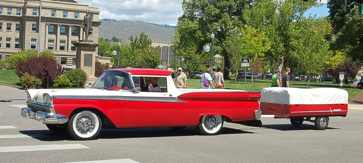
Monday, May 22, 2017

13) Final Adjustments - California Here We Come

Abe looks towards California
(Downtown Boise, Idaho)

A Final Tune-up
We are now just a week away from beginning our expedition. The past few weeks were spent making some final adjustments to satisfy my worries and to assure that this trip will be as trouble-free as possible. A couple of features have also been added to the Ranchero.

New Tonneau
A tonneau cover, which makes the Ranchero look a little more sporty was added to protect the luggage from the elements. I've always been reluctant to add such a cover because it meant changing the stock appearance of the car. The new cover gets a lot of complements. We've seen heavy rains and we anticipate experiencing some of them in the Midwest and on the East Coast. The Cover Shop in Meridian, Idaho made the tonneau. This is the same company which made the tent and the cover for the tent trailer. Their work is first rate and entirely satisfactory.


Mud flap and trailer hitch

A full-length mud-flap was added to the back of the Ranchero. It looks pretty hokey, but it will protect the trailer. I purchased it on eBay. Apparently, it had been sitting in a box since the late 1960s or early 1970s. It comes complete with peace symbols. Oh well!


                                                      Storage space for tools and repair parts
Beneath the bed of the '59 Ranchero is the same floor pan as the '59 Ranchwagon. I have modified the Ranchero so as to allow the utilization of this space for storage of tools and repair parts. Things I don't really want to get into, but if they are really needed, they will be really needed!

By making a couple of adjustments I have also been able to address the issue of the Ranchero running hot. The addition of a manual override switch on the electric fan allows me to turn it on before the thermostat switch does that automatically allowing the fans to come on at a lower temperature, should I think it necessary. I have also moved the setting on the thermostat switch down so that the fans come on earlier on their own. This has helped greatly. Once we're on the road I may make some additional adjustments to the thermostat setting to keep the fan from running too much.

Final Tune
I performed a final tune-up on the Ranchero and set the timing for a setting that I hope will optimize fuel economy. The air fuel ratio was adjusted to a setting to maximize fuel economy yet avoid overheating.

At this point there were some jobs I could not perform. In addition I wanted somebody to review my work. Off I went to the downtown Boise Big O Tire Store for an alignment, brake bleed, a check of my work and a general safety check. In examining the car the mechanics discovered that the driveshaft was an inch and a quarter too short. This apparently happened before my acquisition of the car and when the transmission had been changed. Along with the new transmission a new driveshaft was put in. This driveshaft was too short and out of balance. I had to have a new driveshaft made and installed. I'm glad I did this because I would hate to have discovered the problem in the middle of the Nevada desert. In addition the car drives much better.

Discovering the drive shaft is too short
The only thing that remains to be done is to change the oil, gas up the car and to check the air in the tires of both the vehicle and the trailer. California here we come!


Lincoln contemplates the Ford
(Julia Davis Park, Boise, Idaho)


Saturday, May 13, 2017

(12) Preparations, Sea Trials Part  III


3 Island Crossing S.P., Glenn's Ferry, Idaho
Late October 2016

Let's Go Camping
Fall 2016
          
Even though Linda and I have been camping for over 40 years, we haven't been camping for a while and it's been even longer since we were in our primitive tent trailer.

The Ranchero and the trailer make a great camping outfit. I have to say that this overnight campout to Three Island Crossing State Park Idaho went smoothly. Three Island Crossing was one of the points where the Oregon Trail crossed the Snake River. There is an annual reenactment of the crossing held every summer. The crossing is still treacherous and there have been horses lost during these reenactments.

Image result for 3 island crossing reenactment
Reenactment of Oregon Trail Snake River Crossing
(Internet photo)
We made the decision to be simple in our approach to camping. No need to unnecessarily complicate things here. We have a tent to provide shelter over our heads which has 2 beds in it. When we were first married in 1977 we shared a bed. Now those beds look a little bit smaller. We've decided to each take a side. There is no room for the kids to come along this time.

A Cozy Bed
While we've simplified our approach we decided that the Ranchero gives us the opportunity to carry a little more luggage. We purchased a pair of folding bicycles and they easily fit into the Ranchero.

Unfortunately we were not able to go camping before mid October 2016. We only got in one outing, although we will plan to go again in the spring. The weather was pleasant, although it took me a while to recognize the sound of the leaves falling on the roof of the tent. We feel like are set.

Camp Backyard- April 30 2017

We had hoped to get out of town to a campground. Unfortunately the spring weather would not cooperate. Weather limited us to the backyard, but we thought camping again was worthwhile to assure ourselves that we were taking everything we needed, but no more. The weather was chilly, in the mid-30's, although we stayed warm in the tent trailer. This was reassuring as I'm anticipating some cold nights in Nevada, Utah and Wyoming.

The camp was well equipped and comfortable. We were even able to have a fire, and the price was definitely right! 

Camp Backyard, April 30, 2017

One of the well equipped fire pits at Camp Backyard
Things went smooth and we were able to identify some supplies we need to take along for the trip which is now just weeks away.


Sunday, April 30, 2017

(11) Preparations, Sea Trials, Part II


(2) Dog Valley Days 


One week after the Packard Tour I went on another tour of the Lincoln Highway in California and Nevada. Although this tour was again of the Lincoln Highway in California and Nevada it was completely unlike the Packard tour. This time I was with members of the Nevada chapter of the Lincoln Highway Association. I was able to snag a ride with Jim Bonar, former Director of the Nevada Chapter. This turned out to be a stroke of luck as Jim's knowledge of the Lincoln Highway through the Sierras of California and Nevada is second to none.

I left my blue '67 Ranchero at the parking lot of the casino where we rendezvoused. I was not the only one to leave my classic car behind. All of the cars on this tour had high ground clearance and most were four-wheel-drive. The Dog Valley Route is on forest service roads. I think my Ranchero would have made it, but I would've had to devote three or four days to cleaning it and getting the dust out of all the nooks and crannies. It was better to leave it at back in the paved parking lot. Riding with Jim assured a bonus that I would learn something on this trip as well.

Original Pavement, East of Verdi, Nevada. 
The tour began with the viewing of some old Bridge abutments and sections of pavement of the Lincoln Highway. Only dedicated highway enthusiasts ("Roadies") or the clinically insane become excited over viewing old pieces of broken concrete. The fact that I was one of those getting excited means that I fit into the one of the two categories. Sadly, as this is being written the historic old pavement is threatened with destruction and removal for development.

Border Obelisk and interpretive sign on the Dog Valley Route

Heness Pass Road

We then proceeded up Henness Pass Road and into Dog Valley. Henness Pass Road and Dog Valley is the original route of the Lincoln Highway over the Sierras. It is a road that is steeped in history. Before the Lincoln Highway the road was used to bring supplies to the Comstock mines. Before that it was the Emigrant Trail into California.


Alder Creek Campsite

Very near the dog Valley Route is the Alder Creek campsite of George and Jacob Donner. It is now a beautiful roadside picnic area. Standing there looking out over the peaceful scene it is difficult to comprehend the horrors of the winter of 1846-1847. George and Jacob Donner lost their lives very near this route. George and Jacob did not even make it to the eastern shores of the lake that would later bear their family name. George's wagon suffered damage near Alder Creek. When the wagon was damaged George suffered a serious injury. George, Jacob and their families and Teamsters made camp at Alder Creek. Neither George nor Jacob would survive the winter and never left the Alder Creek campsite.


Plaques at Alder Creek to the Memory of Tamsen and Elizabeth Donner


A tender footnote to this saga involves the story of Tamsen Donner, George's young wife. Tamsen remained strong through the winter and nursed her husband, George. When a relief party arrived at Alder Creek the rescuers and husband George urged Tamsen to leave with the rescue party. Tamsen refused wishing to nurse her husband in the final few hours of his life. After George died Tamsen hiked to the main camp at the east end of Donner Lake. In addition to caring for George in his last hours, Tamsen saw to it that her children were put into the hands of the rescuers, but she did not survive the winter.

Alder Creek, site of George and Jacob Donner camp
Several years ago, The Anthropology Department of the University of Nevada excavated the Alder Creek Site. To assist the dig, Cadaver Dogs were used to identify the places where human remains were present. The remains cannot be detected by humans, but even with the passage of more than 170 years the dogs can detect the presence. Separate teams of dogs each independently identified several points. I was with Greg Palmer last summer (2016) as he marked the places the dogs had identified. Likely one of these is the final resting place of George and Jacob Donner and others who made camp here.

Greg Palmer marking a place identified as
containing human remains


Truckee River Route Petition
Copy Courtesy of Norm Saylor
Truckee River Route

The Dog Valley Route was abandoned for the Truckee River Route by the mid-1920s. There was a petition drive by residents and businesses in Truckee, Reno and San Francisco in favor of the Truckee River Route. Norm Saylor has many of the original petitions that were signed and delivered to the California Department of highways. The new route was 11 miles shorter, avoided several difficult summits and was considered more scenic and also gave additional opportunities for camping and tourist activities. While all of this is true, it has also been argued that an improved Dog Valley Route would have been even shorter than the Truckee River Route and would have been less expensive to construct.

The Truckee River Route evolved from the Lincoln Highway and Victory Highway into US Highway 40 and ultimately into Interstate 80. The fact that Interstate 80 still uses this route is a testament to the Truckee River Route. Nonetheless, Dog Valley serves as a quiet and beautiful reminder of the rich past of this region of the Sierra Nevada.


Truckee River Route of the Lincoln and Victory Highways

Wednesday, April 26, 2017

(19) So it begins: San Francisco to Donner Lake

Day 1, June 9, 2017
Out of the City and under the Bay


Postcard showing Golden Gate and San Francisco-Oakland Bay Bridges as
well as Treasure Island, site of 1938 World's Fair

It was with both a great sense of relief and apprehension that we left San Ramon in the late morning of June 9. Relief because the ordeal we experienced is now over. A little apprehension over what might lie ahead if our bad luck should continue.

From San Ramon we traveled south to Interstate 580. There we pointed the car east to Livermore. In Livermore we stopped for pictures of a restored service station
and also to look at the Duarte Garage which has been restored and is maintained by the Livermore Heritage Guild.
Duarte Garage, Livermore, Ca.


We then took the old Altamont Pass Road to Tracy. This is one of my favorite stretches of the trip. The road and the terrain remind me much of what the road must have looked like during the heyday of the Lincoln Highway. We stopped at the Summit Garage for another picture.
Summit Garage, Altamont, Ca.

Me in front of historic building in Banta, Ca.  
In Tracy we stopped to snap a couple of pictures as well. Then we headed north to Sacramento and Interstate 80. Interstate 80 will take us to Soda Springs and Donner Lake where we will spend a couple of days regrouping and transferring our gear into the 2006 Mustang. Of course, some things will have to be left behind and we will have to consolidate our baggage. From there it was north to Sacramento. Since I had just traveled this route in September, we didn't stop for more than just a couple of photos.
Building In Banta, Ca. Historic photo from Tracy Historical Society

Banta Inn, near Tracey, Ca.


Western Terminus of Lincoln High. from American Heritage
magazine, Vol. 25, No. 4, June 1974
Before Interstate 80

At Sacramento, we picked up highway 80 and began the climb into the Sierras. Before Interstate 80, the trip from our house in the Bay Area to our cabin at Donner Lake could be long and hot. But hey, I was a kid and what was miserable to my parents was an adventure for me. By the time I was 6 or 7 the freeway had swallowed up most of Highway 40. Dad was excited about the time saved, but I have to admit in my young consciousness I missed the rare stops at the "Giant Orange" in the Valley, getting doughnuts in Sacramento for Saturday morning breakfast or Mom dispensing  rations of lemonade from

Giant Orange Juice stands. The one on the right, although way before my time, is closer to those I remember. Internet photos, (the one on the right was apparently from the Tracey Historical Society)
the "Little Brown Jug". The small cups of lemonade were passed back through the station wagon to my brothers and me. They were never big enough.

Little Brown Jug
Any interruption in the trip was, of course, and aggravation for Dad, but was added interest for me. I loved the smell of the Presto Log mill just west of Sacramento and on one very rare occasion being held up by the open drawbridge over the Sacramento River. Overall, my memories of these trips are dim yet parts are vivid and intense. One thing that I can remember about the trips was that they were long and hot. The heat began in Sacramento and rose steadily until Auburn.

The heat would finally break around Emigrant Gap and by the time we got to Cisco Grove and Soda Springs the air was cool and pleasant. Even as a youngster I remember looking at the cabins and lodges along the Yuba River and thinking how inviting they looked.

Cabin along the rushing Yuba River

Entry to Rainbow Lodge

Forest Gift Shop, Popular before I-80 (On the way to San Francisco)
Rainbow Lodge was and still is beautiful. A few years ago Linda and I had breakfast at the rainbow Lodge. It was like entering a time capsule.

Ranchero in front of Rainbow Lodge, on the way to San Francisco


Soda Springs to Donner Lake
Norm Saylor out side his museum, Soda Springs, Ca.

At Soda Springs we came upon Lake Van Norden just south of the highway. Sadly, the beautiful Lake is gone, having been drained for some reason or other. With the lake drained, the micro-climate it created also disappeared. Nothing left but a memory of the beautiful scene.

East of Soda Springs came the ski resorts and utilitarian railroad structures. In the late 30's Skiers arrived via "The snowball Express". Later they came by car.
Our son, Will, sits atop Lincoln Highway
Subway 1994

The China wall


At the summit is tunnel number 6 of  the Central Pacific Railroad.                                                                                                            
Vertical shaft drilled into the middle of Tunnel number 6 to allow the 
Chinese crews to work 4 faces of the tunnel instead of just 2.
A miracle of engineering and tenacity. A tribute to the labors of the Chinese crews and the genius of the railroad engineers who designed this segment of the transcontinental railroad. Much of the rock that was taken from tunnel number 6 was used to construct The China Wall which can be seen just east of the "subway" (underpass) of the early alignment of the Lincoln Highway over Donner Summit.
On the left side of this photo, the 1914 underpass can be seen. On the right is 
the original crossing which used the Dutch Flat-Donner Lake Wagon Road
and made a dangerous crossing through the timber snow sheds.
Before this subway, automobiles passed through the train sheds. At best crossing the tracks through the train sheds was dangerous, at worst it was deadly.

An early crossing through the sheds, The car to the right didn't
make it. (Photo from book "Donner Pass" by John Signor) (This
photo is not of the Donner Summit Crossing.)

Donner Summit claimed a lot of trucks and cars on its curvy downgrade. Many of these wrecks are still visible despite the passage of more than 50 years. A couple of years ago my son Will and I came across the carcass of a 1950 Pontiac. Norm Saylor tells a hilarious story of scavengers picking through a refrigerator truck full of frozen turkeys bound for Thanksgiving tables at Stead Air Force Base near Reno. The FBI rounded up the missing turkeys and admonished the scavengers.

Post Card of Summit Bridge immediately after construction
The overlook at summit bridge puts on a display of the entire history of transportation over the Sierras. Most obvious are the recent additions. Looking east one can see off to the left Interstate 80. Of course, the overlook is part of U.S. 40. Off to the right is the original Transcontinental Railroad. Looking to the south one can see the Lincoln Highway subway, or underpass assuring at least one safe crossing of the mainline. Just west of the subway one can see the Dutch Flat - Donner Lake Wagon Road which served for a year as the Lincoln Highway and crossed the tracks through the Timber Snow Sheds. The road was also the route by which construction materials were brought to build the railroad. Here more than anyplace else one can see that our highways do not simply spring forth from the wilderness, they evolve and build upon what came before.


Somewhat later, the road is paved

When the freeway opened, travel time from Walnut Creek in the bay area to Donner Lake was reduced from the 4 to 6 hour drive to less than 3 hours. Population growth and the attendant traffic has raised travel time back from 3 hours to nearly the 4 to 6 hours that it was in 1960. I feel sorry for travelers making the trip now who won't find a "Giant Orange" at which to quench their thirst and will have to settle for the closest McDonald's at the end of some non descript freeway off ramp.

Original Bronze Plaque for Summit Bridge

Lincoln Highway 1913 alignment, Sheds can be seen to the right
(Stereoscope card)
Whitney Hotel advertisement on rock along 1913 alignment.
The sign reads: "We invite inspection"

Reproduction 1928 marker along Donner Pass